Southern Exposures
Picturing the Antarctic
Ed Osborn
As the final continent to be visited by humans, Antarctica is often referred to as the last place on earth, the end of the world. Yet it might more accurately be thought of as the end of the idea of the world, a place where the constructs and strategies for navigation, representation, and cultural placement break down. On its seemingly endless and mostly featureless glacial plains, perceptual cues for distance, location, and terrain are absent.
Apart from the obvious challenges that this poses for explorers and scientists working there, the problems of representing it visually are also daunting. Most of the photographs produced in Antarctica even today remain faithful to a Romantic tradition of landscape portraiture: a depiction of a site in such a way that a narrative can be read into it, often by including a human figure as a point of reference within the exotic landscape. Any issue of National Geographic that includes a story on “The Ice” will likely feature an image of a deep blue iceberg, preferably sporting a small collection of penguins. In part this is due to the demands for a widely readable image of the place (which is as true now as it was when early expedition sponsors wanted visual justification for their finding). But it also comes from a reluctance to adjust the mode of representation to fit the landscape, especially a landscape that is distant from the rest of the world in ways that go well beyond simple geography. It wasn’t until the advent of aerial photography that representations of Antarctica started to separate from older forms of portraiture. And until this process was fully mechanized, the compositional whims of the photographers tended to stand vividly between the landscape and the images derived from it.
The aerial mapping images produced by the United States Navy beginning just after World War II were the first to provide a new model for looking at the Ice. The images are called trimetrogon photos, an assemblage of three photographs taken simultaneously—one vertical (straight down) and two at oblique downward angles in a direction at right angles to the line of flight.[1] Planes flew in straight trajectory segments, and pictures were taken about once every minute (the timing appears to have been done by hand, since there is some variation in the regularity of the images). This was part of an overall Antarctic mapping campaign that began with Operation Highjump (1946–1948) and accelerated during and after the International Geophysical Year (1957–1958).[2] Aerial photogrammetry had been undertaken in sections prior to this effort, often with the aim of asserting a claim to Antarctic territory (one technique used to these purposes was to argue that the country that had surveyed and photographed a particular area had sovereign claim to it).[3] Prior to the IGY, only the coastline and fragments of the interior of Antarctica had been photographed. The real claim in these pictures is not political (the international agreements worked out in the wake of the IGY had kept the countries involved from coming to blows over the Ice), but was rather cartographic. Quite unintentionally, the pictures showed a new approach to the problems associated with visually representing the interior of Antarctica. And in doing so they provided a visual analogy to the concepts that exploration of the Ice embodied.
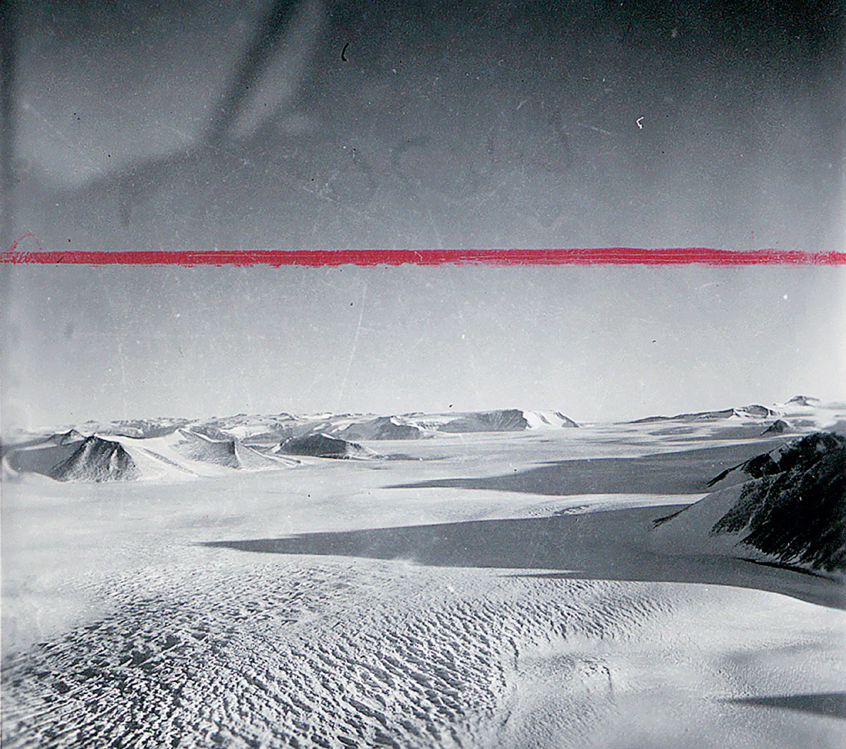
From the earliest expeditions, artists (or, more accurately, naturalists with fine drafting skills) were included to render visible for an audience at home the world of Terra Incognita Australis. While the Romantic conceptions of nature could be easily employed in scenes along the coasts and among subantarctic islands where animal life, visible horizons, and a variety of colors were readily available, the techniques available (both practical and conceptual) broke down when faced with the Polar Plateau itself. How does one render a scene that appears to have no perspective, scarcely any color variation, and no recognizable features? Before rendering begins, what does one make of a landscape so alien and compressed that a narrative derived from the “natural” world has no meaning in it? When Herbert Ponting, the famed photographer on Scott’s Terra Nova expedition (1910–1913), wrote of his disappointment that he would not be going to the Pole, he noted that there was probably “nothing to photograph” on the Polar Plateau anyway. At least in terms of how landscapes were conceived and portrayed at the time, he was quite right. There was nothing there that looked like a normal landscape, much less a photographic one.[4] Often the conditions of flat light (diffuse, with no shadows) or whiteout (nothing but white) rendered any kind of visual representation at best exceedingly difficult and generally meaningless even if it could be accurately achieved. Here the difference between the idea that there is not much to see and the idea that not much can be seen is almost negligible. One can scarcely fault the expedition photographer for declining to confirm visually that, after all the hardships endured to get to the end of the world, there was nothing to photograph, much less an enormous amount of that nothing.
Ponting’s remark was part of a slow process of understanding that the exploration of Antarctica was a fundamentally different endeavor from the kinds of exploration that preceded it. Where voyages to other areas yielded cultural encounters, goods, and additions to scientific and cartographic knowledge, Antarctica provided only the latter, and for a long time not very much of it; the ideas that informed the heroic era of exploration in the rest of the world had no purchase here. There were few trophies to bring back, only uncertain territorial claims and a list of “firsts”: first to set foot in Antarctica, first at the Pole, first to traverse it entirely. It is the only place where “an unknown white spot on a map ... would end up known as a white spot.”[5] It is not for nothing that both the continent and the conditions on it are often referred to as a “white darkness.”
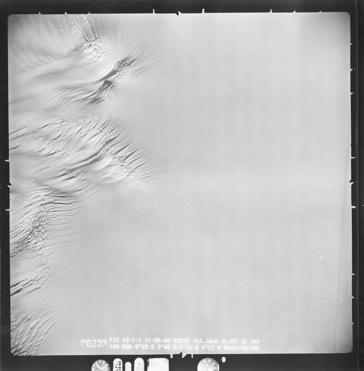
In the aerial photographs, however, the enormity of the nothingness that Ponting could not imagine his way into is made visible. The size is identified not so much by the content of the images themselves, in which the scale is often quite unclear, but rather via the mechanical and cartographic information burned onto their edges. These serve as a substitute for horizon lines and other traditional perspective markers that normally make landscape images readable. Given this detached framing (determined by the direction and altitude of the plane rather than a human eye to a viewfinder) and the superimposition of mapping information, these images substitute the aesthetic intentionality of the photographer’s eye with a cartographic framework to order the blank land depicted within them. It is the introduction of this framework that allows the landscape of ice to be seen in a way that is not compromised by the traditional conception of landscape representation.
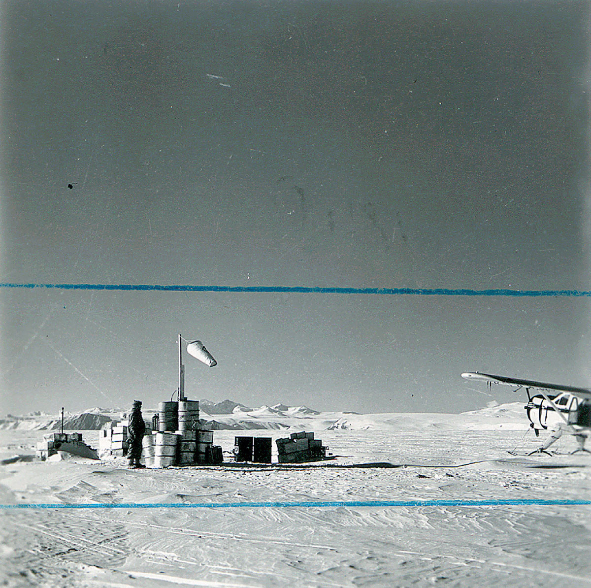
Of course, the impulse to inscribe the Antarctic continent with information in these images did not stop with the imposition of a photographic grid across it. The prints often have the names of features written onto them, as if to reassure the viewer that they are indeed looking at a landscape. Where this was not possible sometimes a slightly more oblique locational reference is made, such as “looking east, going north.” The place names themselves are often an odd match with the sites they inhabit. The area seen and visited in Antarctica prior to the 1950s was relatively small in comparison to all that had not yet been visited, and there were fewer areas still that had much time spent in them. The lack of an indigenous human culture meant that the places were completely unnamed, and not just unnamed by visiting explorers. So the naming process that went with exploration here was far more compressed than in other areas of the world: in the 20 years following World War II, the continent was completely mapped and all the largest features that before then were either unseen or undesignated were given names.
These factors, combined with the immense scale and general strangeness of Antarctica, meant that the fit between the things named and the names applied to them was often at best rather strained. Recoil Glacier, for instance, was named in 1963 after a visiting geologist “was said to have recoiled in disgust at finding little of interest there, and not what he expected.” Mistake Peak’s name resulted from a 1957 survey party climbing the mountain “in the mistaken belief that they were on Shapeless Mountain.” Shapeless Mountain, in turn, found its name because “it appeared shapeless from almost every direction.”[6] Given the other perceptual and conceptual adjustments explorers needed to make there, it does seem oddly natural that only in Antarctica does the notion of a mountain that is shapeless make any sense at all. Ditto for a mountain named after a type of mirage: Mount Supernal.[7] In addition, the naming of places for everything from expedition members to dogs to items of food (Oates Piedmont Glacier, Lake Vanda, and Biscuit Step, respectively) highlights the difference between the immense Antarctic terrain and the limited framework of language that the explorers brought with them to categorize it. While no one would expect that the early explorers to Antarctica would come equipped with a poetic eye and a surfeit of literary skills, it is hard to think of another place where the place names and places named seem so mismatched. Looking at these aerial photos it is still difficult to reconcile the features in these almost unearthly images with the imaginations that christened them with names like Co-Pilot Glacier, Veto Gap, and Sponsors Peak.
As these photos were slowly being produced and concurrent with the IGY, the British Commonwealth Transantarctic Expedition took place. It was a curious expedition in that its intent—to complete the cross-continental journey that Shackleton began in 1914 but never finished after his ship was crushed in the sea ice—seemed based more on vague national glory than scientific purpose. Some gravity and seismic measurements were made as the expedition traveled, but not much other science was conducted. Led in sections by Vivian Fuchs and Edmund Hilary, it was heroic exploration in a time when such national heroics seemed a bit anachronistic, especially as the IGY looked to the future in providing the model for international scientific cooperation that was used in the exploration of space.
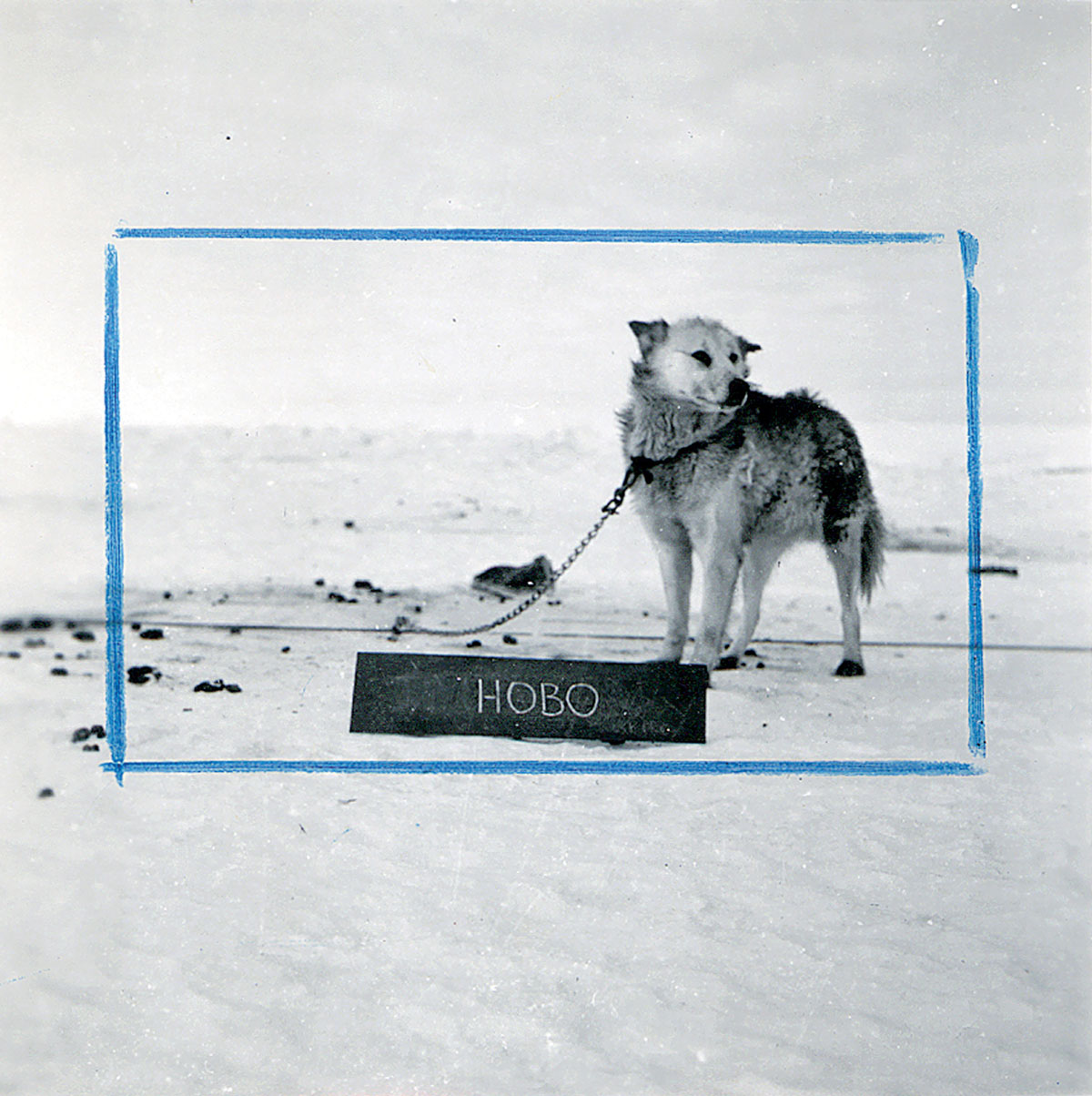
The expedition was heavily publicized and the demands of that publicity naturally affected how the expedition was pitched to the public. Here we can see how the visual representation of the Ice worked (and still does work) in the popular imagination. Many of the images of the expedition are framed in the traditional ways, with a horizon line firmly established, or a human figure to provide an orientation in the images—nothing like this would look the least bit out of place in any issue of National Geographic. There are numerous staged photos showing men and equipment, along with several dozen photos to personalize the dogs on the trip (they stand behind wooden boards that display their names). In the archives of Antarctica New Zealand, matching pairs of many of these publicity images can be found. One of each pair is the original image, the other is the same photo with crop marks drawn on it. Here one can see what is really fit for print in the mind of the editors of the day, particularly in the case of the landscape photographs. Where the photographer included a large expanse of foreground ice or overhead sky, the photo editor would cut these elements down so that the horizon or human elements appeared more prominent. While this was understandable given the conventions of news publishing followed at the time, these crop marks now look less like simple framing devices than visible artifacts of the limits of what is comprehensible. In trying to make sense of a blank landscape, they show how easy it was for the early visitors to Antarctica to find themselves inadvertently atop Mistake Peak.
- The name comes from the usage of three cameras with Metrogon lenses. Trimetrogon photography was widely employed in World War II for reconnaissance purposes and remained the primary form of aerial mapping until supplanted by satellite photography. The images shown with this article are individual shots from the sets of three.
- The International Geophysical Year (1 July 1957–31 December 1958; the “year” lasted 18 months) was started as an international scientific effort to study Antarctica, outer space, and the deep oceans (at the time all little or unexplored areas). It allowed about a dozen countries to set up permanent scientific bases in Antarctica without getting into territorial disputes and provided the model for cooperation in space endeavors.
- Another technique to claim Antarctic territory without setting foot in it was to drop large darts emblazoned with a national flag into the ice along a line of flight.
- Ponting was famous for rearranging elements of “natural” scenes to suit his camera. He requested members of the Terra Nova expedition to pose for his pictures so often that they invented a verb to describe the process: “to pont.” It seems likely that Ponting realized that even his “ponting” skills wouldn’t help much on the Plateau.
- Stephen Pyne, The Ice (Iowa City: University of Iowa Press, 1986), p. 115.
- From the Provisional Gazetteer of the Ross Dependency, A.S. Helm, editor, New Zealand Geographic Board, 1958, and Supplements to the Provisional Gazetteer of the Ross Dependency, Volumes 1–4, 1960, 1963, 1964.
- Supernal mirages are caused by light that is refracted by atmospheric temperature inversions (warmer air hanging above colder). Among other effects, this causes glacial ridges and other surface features to loom high into the air.
Ed Osborn is an artist based in Berlin and represented by the Catharine Clark Gallery, San Francisco. He is developing a series of artworks based on perceptions of Antarctica, the first of which was recently exhibited in New Zealand. He hopes to get to the Ice before it melts.
Spotted an error? Email us at corrections at cabinetmagazine dot org.
If you’ve enjoyed the free articles that we offer on our site, please consider subscribing to our nonprofit magazine, which includes unlimited access to all our archives.