Beginning the End
In the zero thickness of the International Date Line
Jon Calame
A few things are certain about the passage of days and nights: now we face the light, now we hide from it, moving in perfect circles around the axis of the earth. We plunge into darkness and out again through fixed turnstiles of twilight and dawn. To use the modular language of linear time while spinning on a globe is to risk entanglement with “some spurious concept ... nothing but the ghost of space haunting the reflective consciousness.”[1]
For instance, at each moment there are two calendar days afoot, occasionally three.[2] Each day lasts a day at any fixed location but has a life span of exactly forty-eight hours on the globe: the first twenty-four as it “pushes the previous day out of existence ahead of it” and another twenty-four as it is “squeezed into oblivion” by its successor.[3]
Another example: after 1750, sailors on long ocean journeys measured physical progress east or west in degrees, minutes, and seconds of longitude when they measured the hours, minutes, and seconds of discrepant time between an untouched home port chronometer and another adjusted optically each noon, with a ritual observed by Melville in his 1850 novel White Jacket:
“Twelve o’clock reported, sir,” says the middy.
“Make it so,” replies the captain.
And the bell is struck eight by the messenger-boy, and twelve o’clock it is.
A minor wrinkle in trans-Pacific shipboard timekeeping had emerged in 1522 when Antonio Pigafetta, a survivor of Magellan’s voyage, verified Ismail Abu al-Fida’s 1323 hypothesis regarding a “circumnavigator’s paradox,” which held that exactly one day would be inevitably lost by long-distance travelers “bearing the Sun company.” Prior to 1884, sailors resolved the paradox by making routine adjustments of plus-or-minus twenty-four hours in their ship’s log somewhere in the far west Pacific. These de facto date lines, determined by nationality, customary prime meridian, or cartographer, served well enough while traffic across the lines was light.

By the early nineteenth century, however, distances between major destinations seemed to be shrinking quickly.[4] Heavier traffic, faster journeys, and more costly cargo introduced increasingly large flows of capital between and across continents. Major political and commercial agents eventually pooled their frustrations in an international consortium to curtail “the thousand engagements broken by the discrepancies of time.”[5] They funded research, hired experts, and hosted an extensive series of deliberations[6] about what, exactly, should be done about rife timekeeping “discontinuities.” Isolated struggles had hardened into a pitched battle between planetary motion and commercial punctuality.
In 1884, these efforts culminated in the International Meridian Conference in Washington, DC. Forty-one delegates from twenty-five countries attended the Washington meeting and agreed upon a universal Prime Meridian at Greenwich,[7] noting the convenience of an anti-meridian 180° away falling through the western Pacific. Consensus regarding placement of the date line was viewed as a vital step towards synchronization of physical movement in calendar time—shunting westbound cargo into tomorrow and eastbound cargo into yesterday—without which, it was claimed, confusion would result for the traveler.
Of course, even now it is rare to find a private citizen rushing across the Pacific to keep appointments on the other side. The more influential consumers of regulated, synchronized time were the telegraph companies, railroad managers, astronomers, and colonial surveyors who appealed to their governments for time uniformity in order to facilitate the “intimate intercourse of civilized peoples” and keep the wheels of international commerce spinning smoothly.
Prior to adoption of Standard Time in the US, for example, Wisconsin used thirty-eight different local times and the traveler passing through was obliged to adjust his timepiece accordingly. But the shift to Standard Time was not without detractors. In Bangor, Maine, where citizens on the far edge of the proposed Eastern Standard Time would experience a maximum displacement of local time, associations between sunlight and working hours were jolted out of their traditional alignment and heating costs increased during darker winter afternoons. In reply, Mayor Frederick Cummings cited “the immutable laws of God” when he vetoed a compliance initiative in 1883 supported by his political rivals. Bangor’s public clocks kept two times (local and EST, Democratic and Republican, respectively) until Cummings was overruled by the state legislature in 1887.[8]
Meanwhile, advocates marketed Standard Time throughout the 1880s. They offered reassurance to members of the general public who questioned the need for so much conformity: “We do not, of course, wish to suppress local time in common life ... we do not dream of forcing the population of certain countries to rise at noon, nor of forcing others to dine at midnight.”[9] In the end, the world’s civilian population was obliged to adopt Standard Time as specified by the observatories, distributed by the telegram, and apportioned by the railroads. “Henceforth,” as one historian has noted, “the localities are no longer spatially individual or autonomous: they are moments in the traffic that makes them possible.”[10]
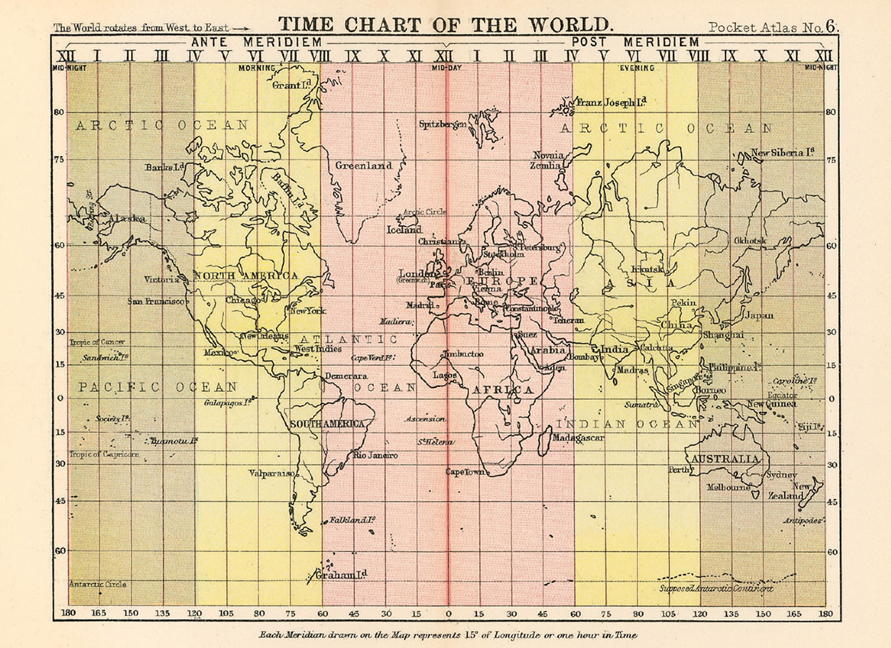
Localities into moments, more ghosts of space. Inquiring about time, space is consulted, and inquiring about space, time is invoked[11] as “every expansion of the physical milieu makes it more important to do something about time.”[12] Proper functioning of the standardized grid of days and hours requires a fixed anchor (0°, or Prime Meridian), which in turn fixes the location of a calendar reset switch (International Date Line, or anti-meridian) engineered to trigger upon contact “that unnatural yet unavoidable jump of twenty-four hours”[13] and enable maritime punctuality.
These imaginary lines are the cartographic parentheses girdling a global system of uniform time zones that gradually replaced intuitive “local time” and allowed for the upscaling of predictable, profitable long-range commerce on sea and land. Still, the “so-called International Date Line” that appears on most maps after 1900 was adopted only customarily “among the commercial steamships of the principal maritime countries.”[14] It had to be located somewhere, it might have been located anywhere,[15] and it was intended to follow the 180th meridian only “as closely as political and geographic circumstances will admit.”[16]
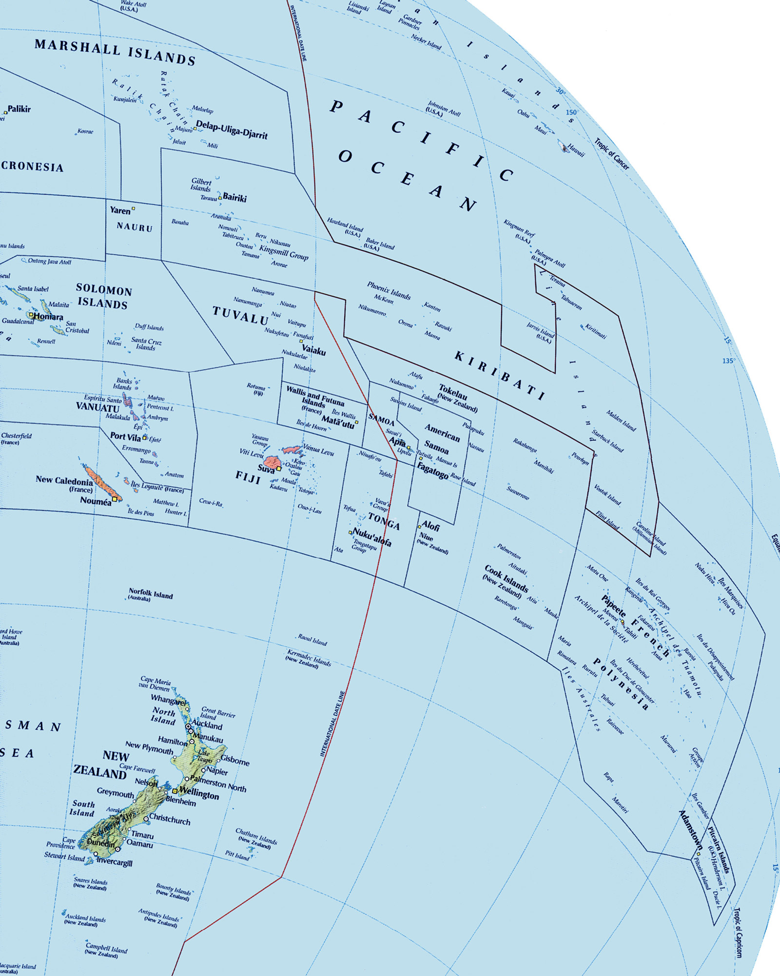
Routinely gerrymandered to skirt national boundaries, the date line now deviates as much as 2,020 statute miles eastward and 520 westward from the 180th meridian designated in 1884. Migrations began as early as the 1840s, when the economic interests of the Philippines turned from Spain’s Mexican ports to the Dutch East Indies and the country was officially moved from the eastern to the western side of the de facto date line. When the United States purchased Alaska in 1867, the de facto date line was deflected eastward through the Bering Strait and westward around the Aleutian Islands to capture all formerly Russian territory in one American day. The Samoan archipelago had traditionally observed an Asian day, but in 1892 King Malietoa relocated his country from the western to the eastern side of the de jure date line in order to strengthen ties with American businesses, allowing for the celebration of July 4th twice that year. In 1995, the Republic of Kiribati ended calendrical segregation by deflecting the de jure date line dramatically eastward (almost as far as 150° west), unifying the sprawling nation in a single Asian day.
The International Meridian Conference, with a neat piece of cartographic cosmetic surgery, rendered possible the impossibility of keeping one-way time on a rotating sphere. The operation left a discreet scar in the far western Pacific. The traditional frontier where East met West—always at the map’s edge—was enveloped by the de jure date line. This sleight of hand concluded the western narrative in which Ulysses ruptured the Mediterranean boundary, Columbus ruptured the Atlantic boundary, Magellan ruptured the Pacific boundary, and, no oceans remaining, Melville’s Ahab “is full stop” at “the end of the UNKNOWN.”[17] The imaginary margin of the known had narrowed to zero thickness: a line.
Arriving late in the western Pacific, one colonial power still sought the uncharted and tenantless spaces formerly in abundance there. In 1947, the United States undertook one more misadventure athwart the dismantled frontier when it assumed trusteeship of two thousand islands clustered near the 180th meridian to create the “Pacific Proving Grounds.” Thousands of islanders were evacuated to allow for the detonation of 102 nuclear weapons. A contaminated cloud formed, drifting for years and hundreds of miles, over into the day before and back again.
- Henri Bergson, Time and Free Will (New York: Harper & Row, 1960), p. 99.
- Interpenetrating time zones resulting from large east-west deflections along the de jure date line allow three calendar days to be simultaneously observed for one hour out of every twenty-four. For example: when it is 11:30 pm Tuesday night in Samoa, it is 5:30 am Wednesday morning in New York City and, strangely, 12:30 am Thursday morning on the Kiribati Islands.
- James Stokley, “The Day and the Date Line,” The Scientific Monthly, vol. 74, no. 4 (April 1952), p. 238. The snub-nosed prow of each new day, cutting into and “squeezing” out the old, is the International Date Line. Of special interest is Stokley’s reliance on spatial metaphors; Bergson observed that “as soon as we try to measure [time], we unwittingly replace it by space.”
- Regarding the linkage of European cities and hinterlands by rail, Heinrich Heine noted in 1843: “I feel as if the mountains and forests of all countries were advancing on Paris. Even now, I can smell the German linden trees; the North Sea’s breakers are rolling against my door.”
- Leonard Waldo, “The Distribution of Time,” Science, vol. 1, no. 23 (4 December 1880), p. 277.
- International conferences directly related to the standardization of time, distance, and commerce included: the 1879 Conference on International Telegraphy in London; the 1881 Conference of Berne to regulate railroad transportation; the 1881 General Time Convention in New York (later to become the Association of American Railroads Convention); the 1881 third International Geographic Congress in Venice; the 1881 International Association for the Reform and Codification of the Law of Nations in Cologne; the 1882 American Society of Civil Engineers in Washington, DC; and the 1883 seventh International Geodetic Conference in Rome, culminating in the Meridian Conference of 1884.
- Following animated debate, delegates in the affirmative: Austria-Hungary, Mexico, Chile, The Netherlands, Columbia, Paraguay, Costa Rica, Russia, Germany, Salvador, Great Britain, Spain, Guatemala, Sweden, Hawaii, Switzerland, Italy, Turkey, Japan, United States, Liberia, and Venezuela; in the negative: San Domingo; abstaining: Brazil and France.
- Carlene E. Stephens, On Time: How America Has Learned to Live by the Clock (New York: Bulfinch Press, 2002), pp. 119–120.
- Editorial, Science, vol. 3, no. 64 (25 April 1884), p. 518.
- Wolfgang Schivelbusch, “Railroad Space and Railroad Time,” New German Critique, no. 14 (Spring 1978), p. 40.
- Accordingly, astromoner Friederich Bessel coined the term “light-year” in 1838 to describe units of distance (10.4 of them) between Earth and a star called 61 Cygni, or “Piazzi’s Flying Star.”
- Elias Canetti, Crowds and Power (New York: Farrar, Straus and Giroux, 1984), p. 399.
- Percival Lowell, The Land of the Morning Calm: A Sketch of Korea (Boston: Ticknor & Co., 1885), p. 1.
- Correspondence from Professor George Davidson, formerly assistant in charge of the United States Coast Survey Office in San Francisco, to the American Geographical Society dated 6 August 1899. In “Universal World Time,” Geographical Review, vol. 25, no. 3 (July 1935), p. 484, Helen M. Strong notes that “although this line is used by navigators of all nations, there seems to be no general agreement concerning the name of ‘the line,’ no international agreement has defined it, nor have the nations formally sanctioned it.”
- A popular prerogative of isolated or imperial governments was to establish their own Prime Meridian. Prior to the consensus of 1884, a functional date line might have been situated 180° east or west from prime meridians recognized in Paris, Washington, Rome, Gibraltar, Naples, Copenhagen, Brussels, Rio de Janeiro, Ferro, Cordoba, Lisbon, Madrid, Berne, Pisa, Oslo, Warsaw, Alexandria, St. Petersburg, Jerusalem, Mecca, or Ujjain (central India). Some Talmudic scholars situate a Halachic date line, the Kav Hataarich, 24° east of Jerusalem along the 149° E meridian.
- A. W. Downing, “The Date Line in the Pacific,” The Geographic Journal, vol. 15, no. 4 (April 1900), p. 415.
- Charles Olson, Call Me Ishmael (New York: Reynal & Hitchcock, 1947), p. 119.
Jon Calame is a partner with the non-profit consultancy group Minerva Partners and specializes in post-conflict urban rehabilitation. His book, Divided Cities: Belfast, Beirut, Jerusalem, Mostar and Nicosia (University of Pennsylvania Press, 2009), examines shared sequences of partition.
Spotted an error? Email us at corrections at cabinetmagazine dot org.
If you’ve enjoyed the free articles that we offer on our site, please consider subscribing to our nonprofit magazine. You get twelve online issues and unlimited access to all our archives.