Inadvertent Memory
Surveilling Kosovo
Laura Kurgan
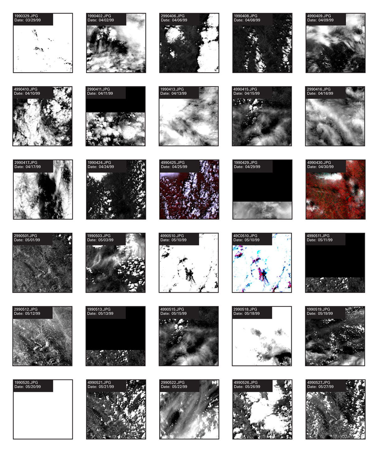
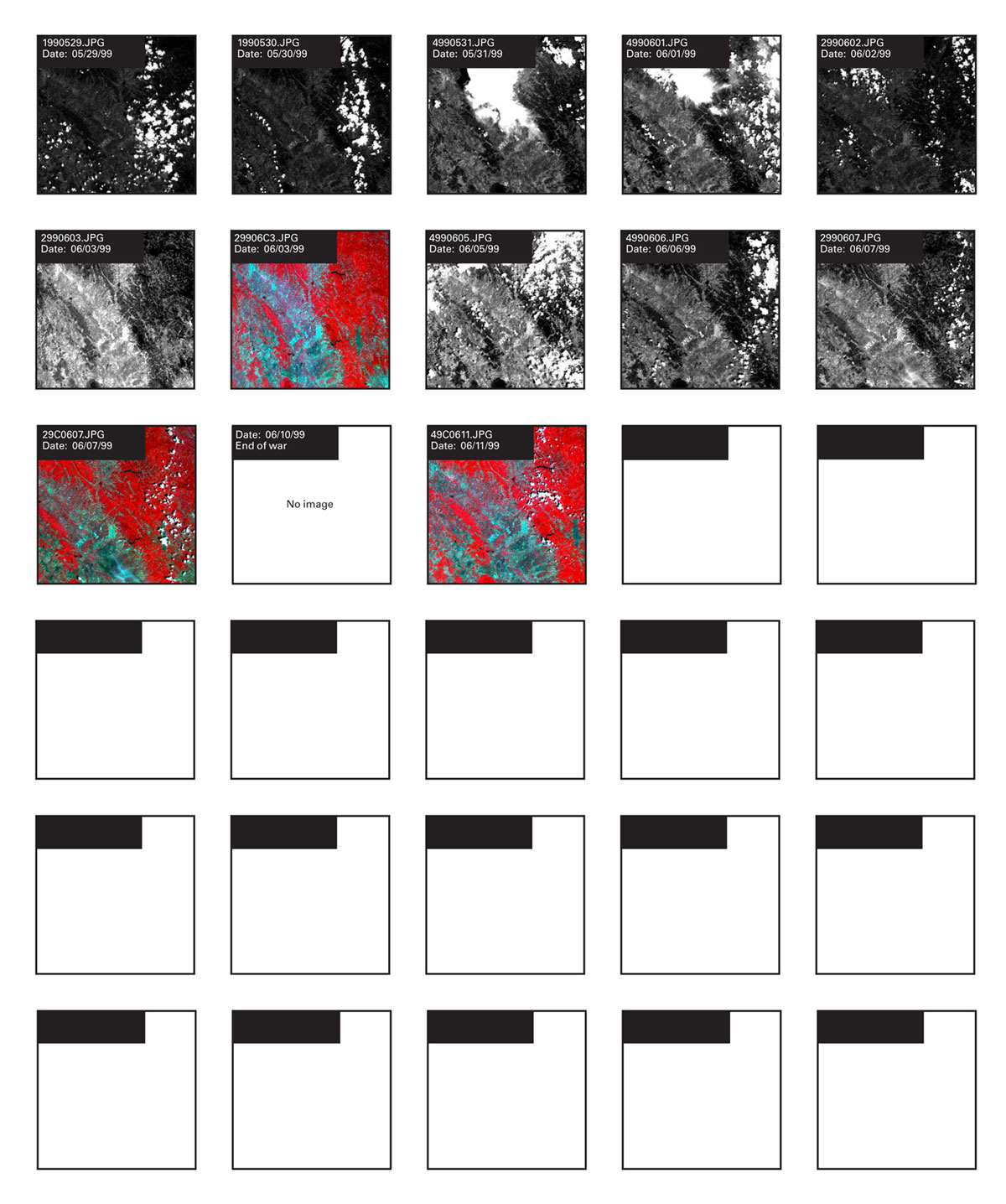
Between March 22 and June 11, 1999, the commercial French SPOT satellites aimed their sensors at this site 42 times, collecting data on the ground from an altitude of 822 kilometers above it. Thousands of megabytes of data about war, displacement, and destruction, because—not by accident—the satellites were passing over Kosovo. Their 10- and 20-meter resolution data were immediately stored and made available publicly, directly from an active war zone, on almost every day of the NATO air campaign. Permanent digital records, created at the speed of light: across sixty square kilometers, in a matter of seconds, the satellites recorded what was happening in the ‘scene’ below, gathering information on the landscape of ethnic cleansing and war.
“Kosovo” names, among other things, the conflict in which classified NATO overhead images were finally released to the public. And they were not simply pictures of the conduct of the war but of its ostensible reasons. This time, in addition to footage of bombs and missiles, the public could see ethnic cleansing in progress: high-resolution imagery of mass graves, refugees in the mountains, burning mosques and villages and organized deportations. It was the war in which satellite images were used as a way of forming public opinion. The manner in which they were released, however—as pictures—showed less the facts-on-the-ground than the ability of the technology to record, in minute detail, these facts. No data, strictly speaking, were forthcoming at press briefings, and certainly not the raw data available commercially. “I won’t talk about what kind of imagery that is,” said the Pentagon spokesman.
This past decade has been one in which satellite data have become more and more accessible to a general public, at higher and higher resolutions. As of January 2000, we can purchase images covering nine square miles at one meter per pixel resolution from the Ikonos satellite for $1000 (if the territory is in the United States) or $2000 (if it’s somewhere else), and more satellites will soon be launched by governments and corporations eager to compete. During the war over Kosovo, however, aside from the copies of satellite imagery released at the NATO and Pentagon briefings, and archived on their websites, images from the SPOT satellites were the highest resolution (ten meter) data available to the public.
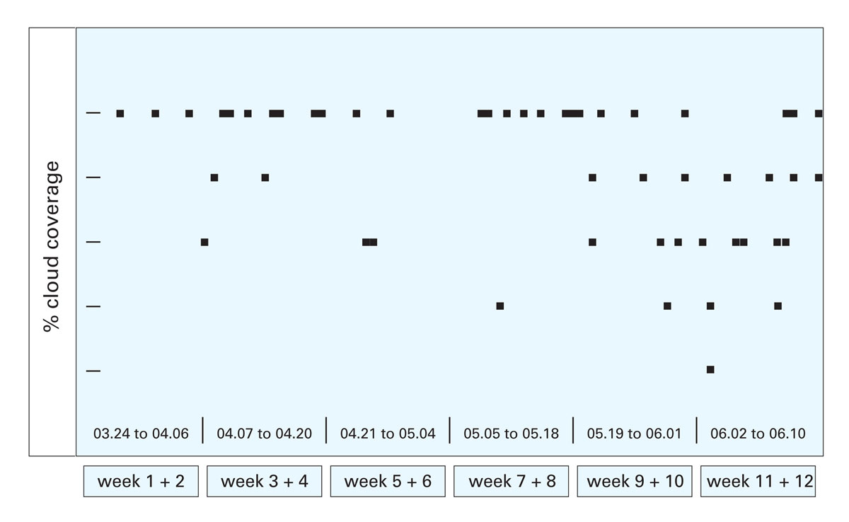
SPOT scene 083-264, pictured here, sixty square kilometers of Kosovo, roughly centered on Pristina: this is just one scene from the vast quantity of images which the satellites record daily and store in databases, ready to be browsed and bought. Every three days, the whole globe is pictured again by the four French satellites. And SPOT is just one of the satellite systems—Landsat, Sovinformsputnik, and Ikonos (Space Imaging), to name only three—which are continuously orbiting the globe, sensing and recording and transmitting and archiving. Millions and millions of pixels, stored in memory, waiting in databases. For a little more than eleven weeks, this area was examined with almost every technology available to the military, governments, civil society, and the news media. Here is a graphical snapshot of a tiny part of the SPOT database, counting the passage of the satellites over one particular piece of ground which during the NATO air campaign came into broader focus: a place to watch over for some, a target for others.
Eighty-one days, forty-two images, most of them were cloudy.
Excerpted from a larger project investigating satellite imagery of Kosovo during the war. To view the project in more detail go to www.virtualmanifesta.com [link defunct—Eds.].
Laura Kurgan teaches in the School of Architecture at Princeton University. Her work with digital information technologies has been exhibited internationally.
Spotted an error? Email us at corrections at cabinetmagazine dot org.
If you’ve enjoyed the free articles that we offer on our site, please consider subscribing to our nonprofit magazine, which includes unlimited access to all our archives.