Trap Streets
The road not taken
James Bridle
In 2001, the Ordnance Survey of Great Britain took the Automobile Association, a motoring organization, to court over copyright infringement, claiming the Automobile Association was using Ordnance Survey maps as the source material for its atlases and town plans.
The Ordnance Survey originates in a 1747 plan to facilitate the subjugation of the Highland clans following the Jacobite uprising of 1745, when Lieutenant Colonel David Watson proposed that a comprehensive survey of Scotland would assist in further campaigns. The result—The Duke of Cumberland’s Map produced under the command of its namesake by William Roy, Paul Sandby, and John Mason—was the first military-quality map of the British Isles, and grew into the Principal Triangulation of Great Britain (1783–1853), which set the standard for the Ordnance Survey’s work.
The Automobile Association, on the other hand, was formed in 1905 with the decidedly anti-governmental intention of helping its members avoid police speed traps, which had been implemented following the Motor Car Act of 1903. Within a few years, it had put up thousands of directional road signs as well, and was the principal erector of such until local authorities took over in the 1930s. From 1910, it also produced maps to guide its members to the best routes, hostelries, and amenities along the newly motorized highways.
The map dispute arose when the Automobile Association was accused by the Ordnance Survey of tracing its careful surveys onto the association’s maps, thereby stealing its data, carefully collated from historical triangulations and aerial photography, from the work of surveyors on the ground and in the air. The process of assembling a map is costly and time-consuming, and its execution forms the prime value of any cartographic business; hence, theft of this nature is taken seriously.
The dispute—which had been rumbling on for some time, first surfacing in the courts in 1996 and dating back as far as 1990—ended when the Automobile Association agreed to pay twenty million pounds to the Ordnance Survey in a settlement agreed just hours before the case was due before a judge. Centrica, the multinational utility which acquired the Automobile Association in 2001, made a statement that “the
The case rested on a series of unique fingerprints within the maps themselves described by the Ordnance Survey’s chief executive Vanessa Lawrence as “design elements in the way we show things which are not obvious to either the user or the copier. When we see the two versions side by side, we can spot clues.” The Guardian reported that these features were pure design elements such as the width of roads, and did not extend to putting misleading features into the maps themselves, corroborating what Lawrence had claimed: “There are some publishers who put deliberate mistakes in their maps. We don’t do that—it would mislead our customers. For us, it’s more about the style we use.”
Other map-makers are not so scrupulous. Anecdotally, many cartographers relate the stories of deliberate errors introduced into maps to prove their provenance, from kinks in rivers and the addition of small buildings to exaggerated curves in roads and the systematic alteration of minor digits in geographic coordinates; nothing that would put the user off-track, but enough to make a map’s actual origin certain. Most of the time, such tricks are indistinguishable from errata, but across enough sheets or data points they form a pattern, and organizations such as the Ordnance Survey employ teams of experts to ferret them out in their competitors’ products.
Such interventions are known colloquially as “trap streets,” a collective term for cartographic fictions with the intent to deter copyists. And, as noted, they may not all be streets: any geographic alteration can be used, from the fabrication of a remote nonexistent town to the mislabeling of the elevation of a mountain range. The existence of such doctored locations is routinely denied in public statements by publishers, even when acknowledged in closed legal proceedings, and so the Ordnance Survey’s denials should be viewed with a certain circumspection.
Open Street Map, whose intention is to create a copyright-free cartography of the world distinct from the proprietary versions that preceded it, is particularly susceptible to such intrusions unwittingly added by its contributors, and so takes pains to warn of the dangers of trap streets. Its copyright guidance references a number of such fictions, many of which have been removed after their exposure.
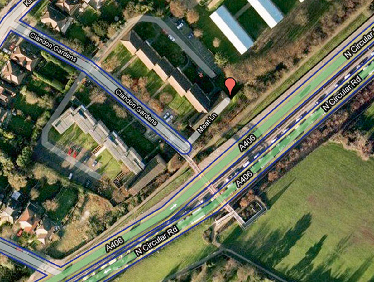
Moat Lane in Finchley, North London—a suburban street specified in the TeleAtlas directory, used as the basis for Google Maps. On Google’s map rendering, it carved, until it was recently removed, at right angles from the end of Clandon Gardens, turning plausibly parallel to the North Circular Road. In satellite view, however, Moat Lane flashed into falsity: Clandon Gardens is a cul-de-sac, and the fat white finger of Moat Lane overlaid trees, gardens, and a pitch-roofed house. It does not exist.
In the market town of Shrewsbury, Kerbela Street once took a hard right and extended right through the Shropshire Learners & Driving Instructor Training center, an unexpected gift for new drivers reliant on satellite navigation. A similar twist used to occur at the foot of Nether Craigour in Edinburgh, where Oxygen Street purportedly ran between two houses. The hairpinned Adolph-Menzel-Ring and Otto-Dix-Ring, real streets in the German town of Zeuthen, were at one time erroneously attached to Wiesenstrasse in a location that the satellite would reveal to be suburban woodlands. The
Not all errors on maps are intentional. “Paper streets” are the result of failed planning applications that have festered long enough to appear on speculative, proposed maps of city’s futures and have thus been incorporated into the official cartographies without ever making the leap to macadam. As such, they may appear on official city maps and land deeds, and even constitute legal rights of way, approved by courts and enforceable by them, and yet undriveable, unnavigable, unobtainable.
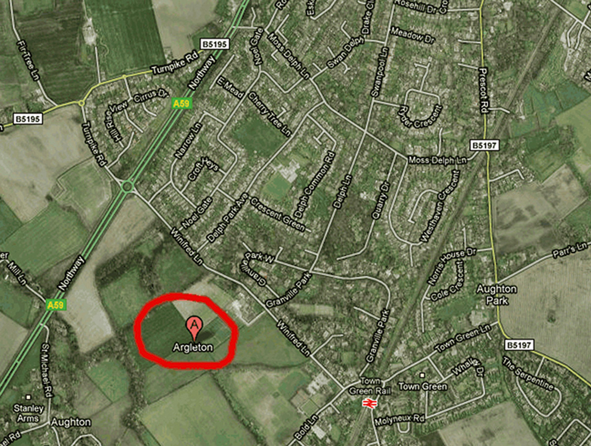
These fictions sometimes extend to phantom settlements. In 2010, the place (because no such term—city, town, hamlet—exists for imaginary locations) known as Argleton disappeared from Google Maps. The poverty of digital archives means its provenance remains a mystery, but it existed for some brief period prior to this date. It lived, as it were, for some time as a settlement within the boundaries of the civil parish of Aughton in West Lancashire. The cascade effect of digital technologies has ensured its survival, partial as it may be, in real estate, employment, and weather databases. At time of writing, TravelRepublic.co.uk lists the West Tower Country House Hotel, the Swan Hotel, Martin Lane Farmhouse Holiday Cottage, the Farmhouse Burscough, and numerous others as potential holiday accommodations in Argleton. Padz.com lists rental accommodation—at least one “
The name Argleton could have come from anywhere: a misspelling of Aughton; an anagram of “Not Large” or “Not real
We must also deal with the legacies of less open, oppressed, or simply confused systems. In 2005, for example, the International Herald Tribune reported the story of Bruce Morrow, an oil engineer for
Morrow also cited numerous maps that reoriented true north by any number of degrees at the local level in order to render them incompatible with a larger view, and compared trying to make sense of them to a game with the
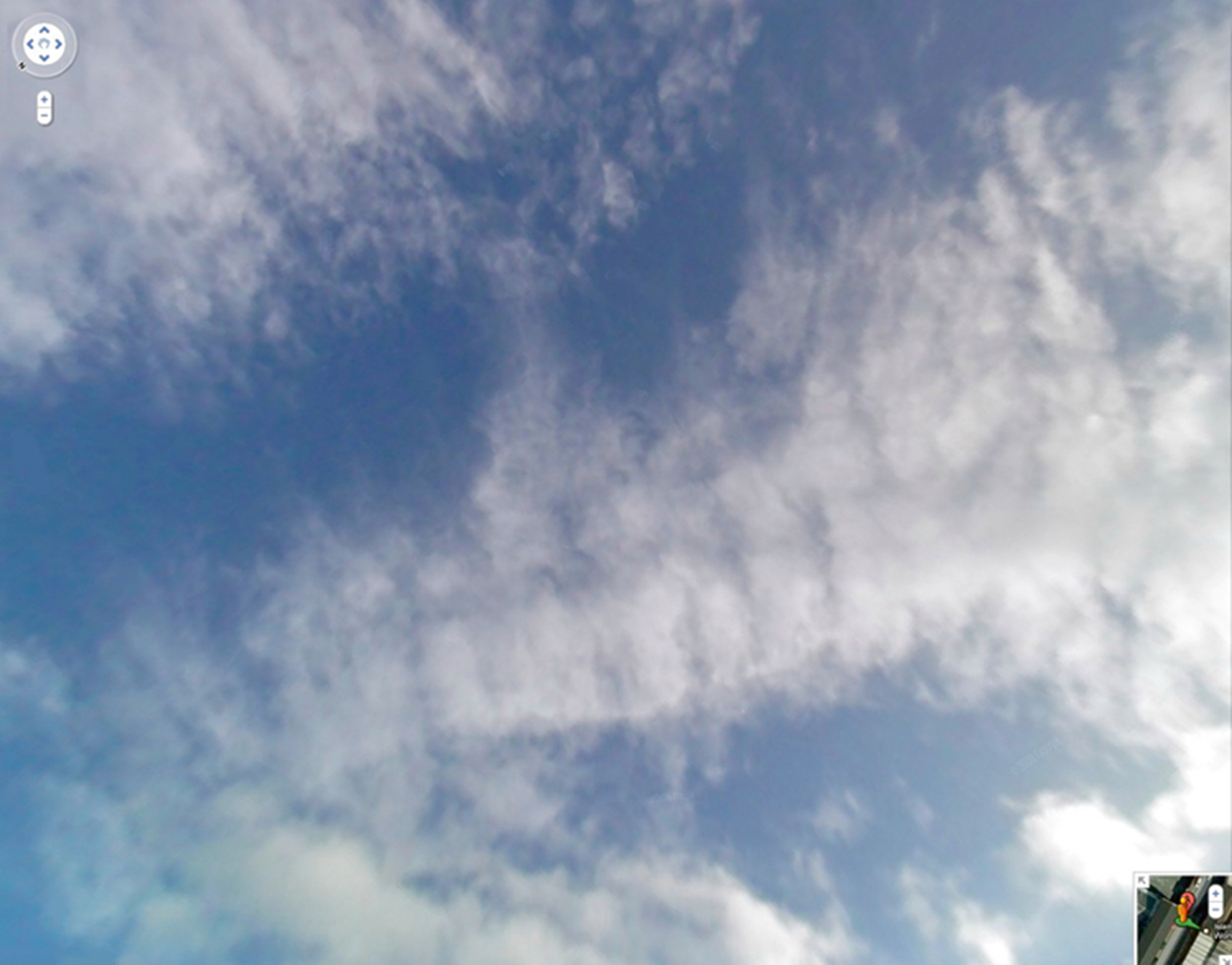
And so what happens when these false places are overlaid on real ones through acquisition or aggregation or intention, algorithmic or otherwise? Ultimately, it is possible to peer through the layers of data and geography to see vistas that should not be possible. “The Sky on Trap Street” is a small online project collecting the views above trap streets in Google Maps. Using Google Street View, it is possible to find the closest real location to a trap street and look up at the correct angle to catch a glimpse of the sky—white fluffy clouds, slightly distorted, besmirched by
James Bridle is a writer, publisher, and technologist. His project for Artangel, “A Ship Adrift,” is available here. His work can be found at booktwo.org.
Spotted an error? Email us at corrections at cabinetmagazine dot org.
If you’ve enjoyed the free articles that we offer on our site, please consider subscribing to our nonprofit magazine, which includes unlimited access to all our archives.